Difference between revisions of "Execution engine"
(→Extension module) |
(→Geospatial libraries) |
||
| Line 56: | Line 56: | ||
var geolib = require('geolib'); | var geolib = require('geolib'); | ||
var terraformer = require('terraformer'); | var terraformer = require('terraformer'); | ||
| + | </syntaxhighlight> | ||
| + | |||
| + | Example | ||
| + | <syntaxhighlight lang="javascript"> | ||
| + | function(observation) | ||
| + | { | ||
| + | var location; | ||
| + | //get wkt json | ||
| + | var loc = JSON.parse(observation.location); | ||
| + | //parse longitud and latutue from wkt text | ||
| + | var point = terraformer.WKT.parse(loc.wkt); | ||
| + | //create a circule with 100 metres radius | ||
| + | var circle = new terraformer.Circle([point.coordinates[0], point.coordinates[1]], 100, 64); | ||
| + | //create location wkt | ||
| + | location = terraformer.WKT.convert(circle.geometry); | ||
| + | //wkt poligon asing created geofense thing | ||
| + | return location; | ||
| + | } | ||
</syntaxhighlight> | </syntaxhighlight> | ||
Revision as of 21:36, 14 October 2016
Contents
CEP (Complex Event Processing — now called Event Stream Processing)
AMTech execution engine is an implementation of a CEP; it encapsulates CEP's complexity in the DAP design.
Execution feedback and/or errors
When an activity is being executed by the execution engine an observationlifecycle type is sent to the activity_lifecycle topic. Some events are reported through the property event, among this events:
- Start of a reasoner (BEGIN)
- End of a reasoner (END)
- Execution errors (ERROR)
The following example illustrates activity "producer": "thingsInBoardroom" reporting action "resourceuri": "/amtech/activities/thingsInBoardroom/reasoners/createThingInBoardroomFromEddystoneBeacon/actions/ReportThingInBoardroom" started "event": "BEGIN"
    {
        "topic": "/activity_lifecycle/thingsInBoardroom",
        "guesttenants": [
            "_ALL"
        ],
        "event": "BEGIN",
        "@type": "/amtech/linkeddata/types/composite/observation/observationlifecycle",
        "producer": "thingsInBoardroom",
        "resourceuri": "/amtech/activities/thingsInBoardroom/reasoners/createThingInBoardroomFromEddystoneBeacon/actions/ReportThingInBoardroom",
        "detectiontime": "Tue Apr 26 21:41:09 UTC 2016",
        "@id": "/amtech/things/observations/983c488f-c3d4-44ec-85f2-795428d12d83",
        "occurrencetime": "Tue Apr 26 21:41:08 UTC 2016"
    }
- This is a strong mechanism you can use to trace the execution of your activities if, at a given moment, you think they are not working as expected.
Security context
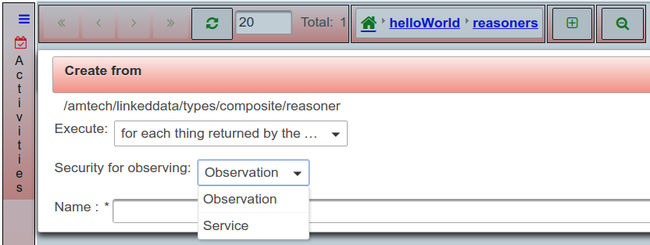
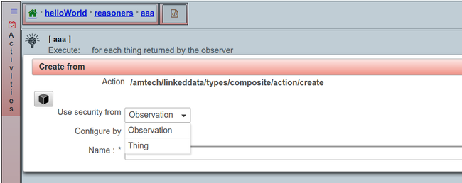
When you create a reasoner, a dialog appears where you should select a name and an execution behavior. In the case where the execution behavior is to visit all the things returned by the observer, you should also select the security context under which the reasoner will run. Two different options are available:
- Observation's security context.
- It means that the observer will return only those things readable by the tenant of the observation. Also, all actions that create objects (things, observations, notifications, etc) will initialize the security context of the object being created with the security context of the observation being consumed.
- Service's security context.
- It means that the observer will return all the things readable by the service. Also, all actions that create objects (things, observations, notifications, etc) will ask you to select between the security context of the observation being consumed and the security context of the thing being visited as the security context of the object being created.
Extension module
EPC
There is a couple of javascript functions available for reasoner's javascript binding. They are:
* epcEncode
* epcDecode
They support the following codings:
- SGTIN-96, SGTIN-198, SSCC-96, SGLN-96, SGLN-195, GRAI-96, GRAI-170, GSRN-96, GSRNP-96, GDTI-96, GDTI-174, GID-96.
Debug
Geospatial libraries
A couple of libraries are available in javascript bindings:
You can make use of these libraries using the variables geolib and terraformer that are initialized as follows:
 var geolib = require('geolib');
 var terraformer = require('terraformer');
Example
function(observation)
{
    var location;
    //get wkt json
    var loc = JSON.parse(observation.location);
    //parse longitud and latutue from wkt text
    var point = terraformer.WKT.parse(loc.wkt);
    //create a circule with 100 metres radius
    var circle = new terraformer.Circle([point.coordinates[0], point.coordinates[1]], 100, 64);
    //create location wkt
    location = terraformer.WKT.convert(circle.geometry);
    //wkt poligon asing created geofense thing
    return location;
}

